+menu -


  • Category Archives Professional News and Thoughts
  • Bernd Resch receives Theodor-Körner Award (Press Release)

    President Dr. Heinz Fischer, Dr. Bernd Resch
    President Dr. Heinz Fischer, Dr. Bernd Resch


    At a ceremony at the University of Vienna Bernd Resch (University of Salzburg and Heidelberg University) received the Theodor-Körner Award in the category of medicine, natural sciences and technology. The Price was awarded by the Austrian Ministry of Transportation, Innovation and Technology (bmvit). In his work, Bernd Resch focuses on assessing human emotions with a variety of sensors including psycho-physiological wearable sensors, “People as Sensors”-based observations, and social media posts from the Twitter network. He aims at finding out how human emotions can be used for urban planning.

    As one of the republic’s most presigious price, the Theodor-Körner Award is bestowed annually as recognition on outstanding scientific work of young scientists. After the ceremony the Federal President of the Republic of Austria, Dr. Heinz Fischer, invited the laureates to the Wiener Hofburg.


    Project Link: http://www.zgis.at/index.php/en/research/research-projects/23-research/144-urban-emotions

  • Supporting Crisis Management after the Typhoon Yolanda/Haiyan on the Philippines.

    The super typhoon Yolanda/Haiyan caused horrible damage on the Philippines. As geographic information like up-to-date images, reports on damages, blocked roads, etc. are oftentimes not available after environmental disasters, the GIScience group at University of Heidelberg spontaneously set up a number of activities:

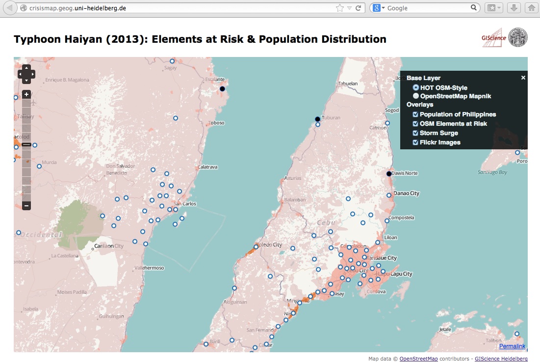
    - A new WebSite http://crisismap.geog.uni-heidelberg.de that visualizes new map layers (“Elements at Risk” and “Population Distribution” for the Philipines). Further it adds a currently less populated Flickr layer and a storm surge layer on top of the H.O.T. base map.
    CrisiMap Interface

    - Due to a request by the crisis mappers also a simple table with the “Elements at Risk“ has been made available as csv-file:
    http://129.206.228.92:8080/geoserver/LiveGeo/ows?service=WFS&version=1.1.0&request=GetFeature&typeName=LiveGeo:planet_osm_gadm&maxFeatures=50&outputFormat=csv

    - An OSM Mapathon for generating a street map of the affected areas:
    http://k1z.blog.uni-heidelberg.de/2013/11/12/uni-heidelberg-osm-mapathon-for-typhoon-yolandahayian-thursday-afternoon-november-14th-2013

    - A live layer of Instagram images; it’s also available as a WFS/WMS layer here.

    Please let us know if you have got any further data to integrate or ideas on improvement! Here are my contact details:
    http://www.geog.uni-heidelberg.de/personen/gis_resch.html

  • How much does the increasing number of PhD degrees advance science?

    A recent article in the German newspaper “Die Zeit” (in German) describes the inflationary granting of a doctorate due to the formal need for a high rate of PhDs and “excellence” of universities – whatever this might mean. One measure for this opaque expression is a high ratio of PhD students per professor, naturally encouraging to hire as many PhD students as possible.
    As a result of this development, plenty of new PhD students theses are elborated without stringent quality control, thus yielding limited to no ouput for the scientific world. This results in a severe decrease in academic productivity in two ways: First, PhD students with a topic of little relevance restrict themselves from being productive in another position; and second, they keep their supervisors off doing other and more useful research by causing much administration and supervision overhead.

    So the questions are:
    - How can we make sure that PhD research is of high quality?
    - How many PhD students does a country even need, and what for?

    Here’s the link to the full article:
    http://www.zeit.de/studium/hochschule/2013-04/promotionen-anstieg-studentenzahlen

  • Visiting Fellow Appointment at Harvard University

    In April 2013, I’ve been appointed Visiting Fellow at Harvard University’s Center for Geographical Analysis (CGA). CGA is a member organisation of the Harvard Institute for Quantitative Social Science (IQSS). It has been founded as a cross-cutting center throughout multiple disciplines including public health, urban design, environmental sciences, computer science and engineering. CGA’s goal is to establish GIScience as a connective element between those disciplines as well in reseach as in teaching.

    My goals here at CGA are basically twofold:
    1.) to develop and teach GIScience related courses. This includes the identification of topics relevant to the labour market and designing courses accordingly. These courses will be offered in the well-established executive training and additionally as online courses for distance-learning degrees.
    2.) to establish a broader research collaboration with other disciplines. A particular focus will be on the connection with the Harvard EECS and Public Health departments and an institutional cooperation with the MIT (the SENSEable City Lab and the City Design and Development group).

    I’m extremely excited about being part of this seminal development and I’m looking forward to collaborating with a wide variety of research groups within Harvard. I’m convinced that we can lay the foundation for a strong GIScience unit in Harvard that is of great importance to other fields of research and education.

    Thanks for having me here!

    http://www.iq.harvard.edu/people/bernd-resch
    http://www.gis.harvard.edu/icb/icb.do?keyword=k235&pageid=icb.page447877

  • Installing a CGI Proxy on Tomcat

    This installation guide has been established using the following system configuration:
    • Windows Server 2003
    • Java JRE build 1.6.0_29-b11
    • Tomcat version 6.0.33 (Windows Service Installer)
    • The CGI-Proxy is written in Python

    1. Download the proxy.cgi file from the OpenLayers web site:
    http://trac.osgeo.org/openlayers/browser/trunk/openlayers/examples/proxy.cgi
    Comment: This file is also included in the OpenLayers API download:
    http://trac.osgeo.org/openlayers/wiki/HowToDownload

    2. Modify the proxy.cgi file to include your domain in the allowedHosts list:
    allowedHosts = ['www.yourdomain.com:8080']
    Comment: Note that you have to include domain AND port here.

    3. Copy the proxy.cgi file to the following folder:
    $TOMCAT_PATH$/webapps/yourApp/WEB-INF/cgi/

    4. Modify the file web.xml of your web app by adding the sections below. You find the file at
    $TOMCAT_PATH$/webapps/yourApp/WEB-INF/web.xml

    Comment: In case the web.xml file doesn’t exist for your webapp, just create it yourself or copy it from another webapp and modify it.
    Comment: the “param-value” for the “executable” parameter has to contain the path to your Pyhton installation.

      <servlet>
          <servlet-name>cgi</servlet-name>
          <servlet-class>org.apache.catalina.servlets.CGIServlet</servlet-class>
        <init-param>
          <param-name>debug</param-name>
          <param-value>0</param-value>
        </init-param>
        <init-param>
          <param-name>cgiPathPrefix</param-name>
          <param-value>WEB-INF/cgi</param-value>
        </init-param>
        <init-param>
          <param-name>executable</param-name>
          <param-value>c:\python25\python.exe</param-value>
        </init-param>
        <init-param>
          <param-name>passShellEnvironment</param-name>
          <param-value>true</param-value>
        </init-param>
        <load-on-startup>5</load-on-startup>
      </servlet>


      <servlet-mapping>
        <servlet-name>cgi</servlet-name>
        <url-pattern>/cgi-bin/*</url-pattern>
      </servlet-mapping>


    5. Modify the file context.xml of your web app by adding the element below. You find the file at
    $TOMCAT_PATH$/webapps/yourApp/META-INF/context.xml
    Comment: In case the context.xml file doesn’t exist for your webapp, just create it yourself or copy it from another webapp and modify it.

      <Context antiResourceLocking="false" privileged="true" useHttpOnly="true" />


    6. Restart Tomcat

    7. To use the proxy with OpenLayers, just include this single line into your code:
    OpenLayers.ProxyHost = "/yourWebApp/cgi-bin/proxy.cgi?url=";