Posted on 15 November 2013 by berno
The super typhoon Yolanda/Haiyan caused horrible damage on the Philippines.
As geographic information like up-to-date images, reports on damages, blocked roads, etc. are oftentimes not available after environmental disasters, the GIScience group at University of Heidelberg spontaneously set up a number of activities:
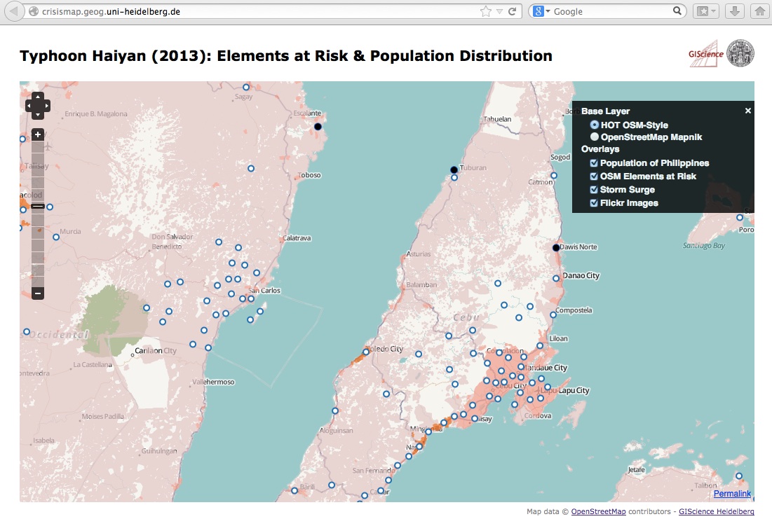
- A new WebSite http://crisismap.geog.uni-heidelberg.de that visualizes new map layers (“Elements at Risk” and “Population Distribution” for the Philipines). Further it adds a currently less populated Flickr layer and a storm surge layer on top of the H.O.T. base map.

- Due to a request by the crisis mappers also a simple table with the “Elements at Risk“ has been made available as csv-file:
http://129.206.228.92:8080/geoserver/LiveGeo/ows?service=WFS&version=1.1.0&request=GetFeature&typeName=LiveGeo:planet_osm_gadm&maxFeatures=50&outputFormat=csv
- An OSM Mapathon for generating a street map of the affected areas:
http://k1z.blog.uni-heidelberg.de/2013/11/12/uni-heidelberg-osm-mapathon-for-typhoon-yolandahayian-thursday-afternoon-november-14th-2013
- A live layer of Instagram images; it’s also available as a WFS/WMS layer here.
Please let us know if you have got any further data to integrate or ideas on improvement! Here are my contact details:
http://www.geog.uni-heidelberg.de/personen/gis_resch.html
- A new WebSite http://crisismap.geog.uni-heidelberg.de that visualizes new map layers (“Elements at Risk” and “Population Distribution” for the Philipines). Further it adds a currently less populated Flickr layer and a storm surge layer on top of the H.O.T. base map.

- Due to a request by the crisis mappers also a simple table with the “Elements at Risk“ has been made available as csv-file:
http://129.206.228.92:8080/geoserver/LiveGeo/ows?service=WFS&version=1.1.0&request=GetFeature&typeName=LiveGeo:planet_osm_gadm&maxFeatures=50&outputFormat=csv
- An OSM Mapathon for generating a street map of the affected areas:
http://k1z.blog.uni-heidelberg.de/2013/11/12/uni-heidelberg-osm-mapathon-for-typhoon-yolandahayian-thursday-afternoon-november-14th-2013
- A live layer of Instagram images; it’s also available as a WFS/WMS layer here.
Please let us know if you have got any further data to integrate or ideas on improvement! Here are my contact details:
http://www.geog.uni-heidelberg.de/personen/gis_resch.html
Leave a comment
Posted on 21 May 2013 by berno
Here’s a nice and quite comprehensive newspaper article about my research (unfortunately in German):
http://derstandard.at/1332324267719/Karriere-in-Technik–Wissenschaft-Mit-30-von-Tamsweg-nach-Boston-und-Osnabrueck
http://derstandard.at/1332324267719/Karriere-in-Technik–Wissenschaft-Mit-30-von-Tamsweg-nach-Boston-und-Osnabrueck
Leave a comment
Posted on 14 January 2012 by berno
I recently read this article in the Austrian newspaper derStandard:
Feuchtgebiete in den Alpen
It’s basically a semi-funny illustration of a ski instructor’s “après-professional” part of a working day.
However, the hammer strikes just at the end – when the short bio mentions his birth place ;-/
Feuchtgebiete in den Alpen
It’s basically a semi-funny illustration of a ski instructor’s “après-professional” part of a working day.
However, the hammer strikes just at the end – when the short bio mentions his birth place ;-/
Leave a comment
Posted on 21 October 2011 by berno
Hey ho!!
First impression of Osna – just great!! The people are extremely friendly, the volleyball team is great fun and my colleagues at university are very far-sighted and cooperative. I really had a blast of a start up here!
For those of you who don’t know where Osnabrück is by now – it’s here
First impression of Osna – just great!! The people are extremely friendly, the volleyball team is great fun and my colleagues at university are very far-sighted and cooperative. I really had a blast of a start up here!
For those of you who don’t know where Osnabrück is by now – it’s here
Leave a comment